
Cemetery Mapping: How Technology Is Digitising Burial Records
Think of your local cemetery. Peaceful, quiet, maybe a little overgrown in places. But beneath the surface lies not just bones and memorials, but a tangled history of who lies where, why, and when. For centuries, these records lived in dusty ledgers, weather-worn stone, or sometimes—nowhere at all.
But here’s the twist: cemeteries are going digital. As odd as it might sound, graveyards are joining the tech age. From drones and GPS to databases and 3D mapping, the field of cemetery mapping is transforming how we preserve the past, honour the dead, and plan for the future.
So why is cemetery mapping gaining traction? And what does it mean for genealogists, historians, and everyday mourners? Let’s dig in—digitally, of course.
Contents
- What Is Cemetery Mapping, Really?
- A Brief (and Morbidly Fascinating) History of Burial Records
- The Technology Powering Modern Cemetery Mapping
- Why It Matters: More Than Just Data
- Challenges in Cemetery Digitisation
- Case Studies: Where Tech Meets Tombstones
- The Future: AI, AR, and Cemetery Metaverses?
- Bottom Line
- FAQs
What Is Cemetery Mapping, Really?
At its core, cemetery mapping is the process of digitally documenting the layout of a burial ground. This includes the locations of graves, headstones, paths, structures, and landscape features.
But modern mapping doesn’t stop at dots on a digital map—it often includes integrated burial records, photos, GPS coordinates, plot ownership, and even interactive virtual tours.
Think of it like Google Maps meets ancestry.com, but with an added layer of local history, public memory, and technological flair.
A Brief (and Morbidly Fascinating) History of Burial Records
Before we jump into high-tech territory, let’s rewind. Historically, burial records were kept by hand—parish books, town registers, or family Bibles.
If the church burned down or the clerk had sloppy handwriting (which happened often), data disappeared. Even now, many cemeteries—especially rural or older ones—have little to no formal documentation of their burials.
Enter: disorganised cemeteries, lost graves, legal disputes, and frustrated descendants.
In the 20th century, some large cemeteries began using CAD software (Computer-Aided Design) to map plots. Still, it was clunky, siloed, and—let’s face it—not very accessible.
Today, we’re entering an era where burial records can be accessed on your smartphone, with accuracy down to the centimetre.

The Technology Powering Modern Cemetery Mapping
Let’s break down the tech toolkit currently digging up (metaphorically) the truth beneath our feet:
1. GPS & GIS: Grave Precision
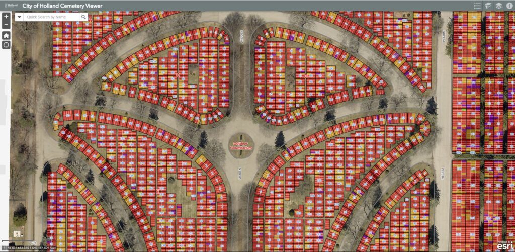
Global Positioning Systems (GPS) allow surveyors to pinpoint graves with exact coordinates. These points are then fed into Geographic Information Systems (GIS)—software that layers spatial data with metadata like names, dates, and epitaphs. It’s like building a cemetery Google Earth.
GIS also allows planners to analyse burial trends, monitor available space, and even simulate future plots.
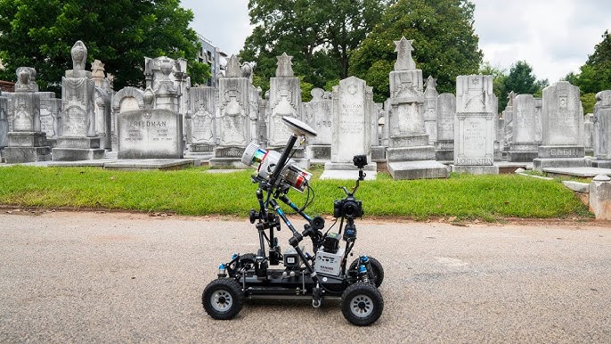
2. Drones: The Eyes in the Sky
Drones equipped with cameras and LiDAR (Light Detection and Ranging) technology are becoming the new graveyard caretakers. They can scan wide areas in minutes, capturing topographical data and aerial imagery that would take humans days to collect.
Bonus: they don’t disturb the peace.
3. Ground-Penetrating Radar (GPR): Seeing the Unseen
GPR uses radio waves to detect disturbances in soil—perfect for locating unmarked or sunken graves. This is especially useful in historic cemeteries, where markers may have eroded or shifted over time.
GPR is like the X-ray of cemetery tech—silent, non-invasive, and incredibly revealing.
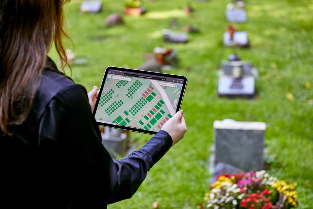
4. Mobile Apps & Cloud Databases: Your Cemetery in Your Pocket
Services like Find A Grave, BillionGraves, and custom cemetery platforms allow users to view, update, and contribute to digital cemetery maps. Families can upload photos, correct records, or even “visit” ancestors via augmented reality.
Suddenly, genealogy becomes a team sport—and a global one at that.
Why It Matters: More Than Just Data
Let’s pause and ask: why digitise the dead?
The reasons are as varied as the stories buried beneath the stones:
1. Genealogy & Ancestry Research
For descendants tracing family trees, a digital graveyard map is gold. It connects the past with the present, making heritage more than just names on a page.
2. Cultural Preservation
Many indigenous, minority, or marginalised communities have underdocumented cemeteries. Technology helps reclaim their histories, ensuring they’re no longer erased—literally or figuratively.
3. Urban Planning & Legal Clarity
As cities expand, it’s crucial to know what lies beneath. Mapping prevents accidental development over old graves, a surprisingly common occurrence in areas with poor records.
4. Environmental & Ethical Planning
Modern cities are running out of room for the dead. GIS tools can help identify space-efficient, green burial alternatives and ensure respectful management of existing cemeteries.
5. Accessibility & Engagement
From elderly relatives unable to travel, to teachers leading virtual history tours—interactive cemetery maps open graves (pun intended) to everyone, anywhere.
Challenges in Cemetery Digitisation
Now, let’s not sugarcoat it—this digital resurrection has its hurdles:
- Data accuracy: Old records are often incomplete or contradictory.
- Funding: Many cemeteries, especially small or rural ones, can’t afford the tech.
- Privacy & ethics: Balancing public access with family sensitivities is key.
- Weather & terrain: Mapping uneven or overgrown landscapes takes time and care.
- Cultural respect: Not all cultures welcome digital mapping of sacred sites.
So yes, mapping the dead requires delicacy, diplomacy, and a whole lot of patience.
Case Studies: Where Tech Meets Tombstones
- New York City Municipal Cemeteries are using GIS to manage over one million burials, helping descendants locate ancestors with surprising ease.
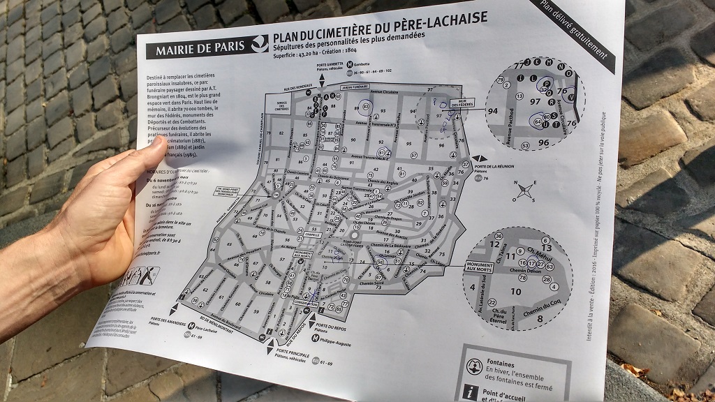
- Père Lachaise in Paris, one of the most visited cemeteries on Earth, now offers a GPS-enabled app to guide visitors to famous graves.
- Indigenous-led projects in Australia and Canada are using GPR and drone mapping to identify unmarked graves from colonial-era boarding schools—bringing healing through truth.
These aren’t just technological marvels—they’re acts of remembrance and justice.
The Future: AI, AR, and Cemetery Metaverses?
Where is all this headed?
Imagine standing in front of your great-great-grandfather’s grave, pointing your phone, and seeing a hologram of his face, his life story unfolding in augmented reality.
Or perhaps a digital assistant helping you find your plot in a virtual cemetery before you’ve even passed on (morbid, but efficient?).
As AI and AR evolve, cemeteries may become interactive archives—part museum, part memorial, part map. Digital immortality is no longer a sci-fi fantasy; it’s on the horizon.
Bottom Line
At first glance, the idea of digitising graves may sound cold or clinical. But in reality, it’s deeply human.
Cemetery mapping bridges the gap between memory and technology, giving voice to the silent, presence to the absent, and connection to those left behind. Whether you’re a historian, a grieving relative, or a curious tourist, this digital resurrection has something to offer you.
Wow that was strange. I just wrote an extremely long comment but after I clicked submit my comment didn’t appear. Grrrr… well I’m not writing all that over again. Anyhow, just wanted to say fantastic blog!
It’s not my first time to visit this web site, i am browsing this website dailly and get good facts from here all the time.
Appreciation to my father who informed me on the topic of this web site, this website is really amazing.